Question : Why is India taking keen interest in resources of Arctic Region?
(2018)
Answer : The Arctic is the region around the North Pole, usually understood as the area within the Arctic Circle. It includes parts of Russia, Scandinavia, Greenland, Canada, Alaska and the Arctic Ocean. Himadri Station is India’s first Arctic research station located at Spitsbergen, Svalbard, Norway. It is located at the International Arctic Research base, Ny-Ålesund. It was inaugurated on the 1st of July, 2008. Arctic Region is not considered as a global common and its discourse ....
Question : Define mantle plume and explain its role in plate tectonics.
(2018)
Answer : A mantle plume is an upwelling of abnormally hot rock within the Earth’s mantle. As the heads of mantle plumes can partly melt when they reach shallow depths, they are thought to be the cause of volcanic centers known as hotspots and probably also to have caused flood basalts. It is a secondary way that Earth loses heat much less important in this regard than is heat loss at plate margins. Two of the most ....
Question : What are the consequences of spreading of ‘Dead Zones’ on marine ecosystem?
(2018)
Answer : Dead zones are hypoxic (low-oxygen) areas in the world’s oceans and large lakes, caused by “excessive nutrient pollution from human activities coupled with other factors that deplete the oxygen required to support most marine life in bottom and near-bottom water” according to National Oceanic and Atmospheric Administration (NOAA). Historically, many of these sites were naturally occurring. However, in the 1970s, oceanographers began noting increased instances and expanses of dead zones. These occur near inhabited coastlines, ....
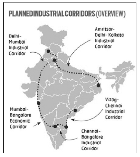
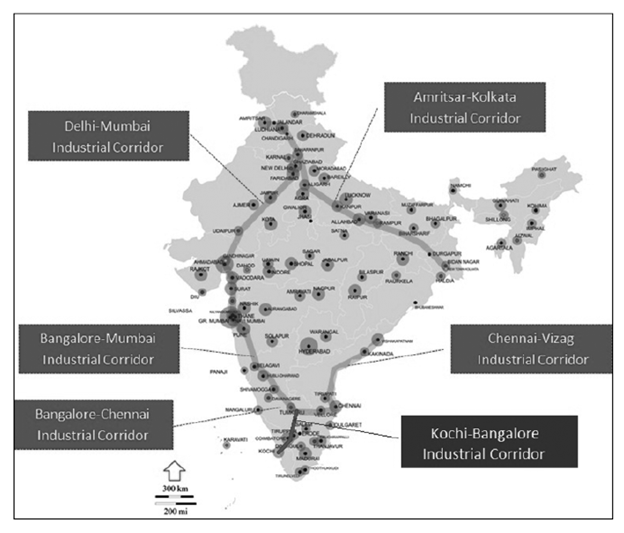
Question : What is the significance of Industrial Corridors in India? Identifying industrial corridors, explain their main characteristics.
(2018)
Answer : An industrial corridor is a package of infrastructure spending allocated to a specific geographical area, with the intent to stimulate industrial development. An industrial corridor aims to create an area with a cluster of manufacturing or other industry. Such corridors are often created in areas that have pre-existing infrastructure, such as ports, highways and railroads.
Question : Defining Blue Revolution, explain the problems and strategies for pisciculture development in India.
(2018)
Answer : Blue Revolution, the Neel Kranti Mission has the vision to achieve economic prosperity of the country and the fishers and fish farmers as well as contribute towards food and nutritional security through full potential utilization of water resources for fisheries development in a sustainable manner, keeping in view the bio-security and environmental concerns. Main focus is creating an enabling environment for integrated development of the full potential of fisheries of the country, along with substantially ....
Question : “The ideal solution of depleting groundwater resources in India is water harvesting system.” How can it be made effective in urban areas?
(2018)
Answer : Groundwater is the most preferred source of water in various user sectors in India on account of its near universal availability, dependability and low capital cost. As per the latest assessment, the annual replenishable ground water resource of country has been estimated at 433 billion cubic meter (bcm), out of which 399 bcm is considered to be available for development for various uses. The irrigation sector remains the major consumer of groundwater, accounting for 92% ....
Question : Discuss whether the formation of new states in recent times is beneficial or not for the economy of India.
(2018)
Answer : Ever since India attained independence, it has always faced pressure to create new administrative units from within. This has led to a lot of changes happening and in recent times several new states have been created with varying effects on the economy.
Benefits of new states to the economy include:
Question : Why is the Indian Regional Navigational Satellite System (IRNSS) needed? How does it help in navigation?
(2018)
Answer : IRNSS is an independent regional navigation satellite system being developed by India. It is designed to provide accurate position information service to users in India as well as the region extending up to 1500 km from its boundary, which is its primary service area. An Extended Service Area lies between primary service area and area enclosed by the rectangle from Latitude 30 deg South to 50 deg North, Longitude 30 deg East to 130 deg ....
Question : In what way can floods be converted into a sustainable source of irrigation and all-weather inland navigation in India?
(2017)
Answer : In general parlance, the word ‘flood’ is attached with destruction and devastation.
Question : What characteristics can be assigned to monsoon climate that succeeds in feeding more than 50 percent of the world population residing in Monsoon Asia?
(2017)
Answer : The word monsoon has been derived from an Arabic word ‘mausim’ which means season. It denotes a season in which the winds are completely reversed. In short, reversal of winds is called monsoon.
Following are the salient characteristics of the Monsoon Climate:
Reversal of winds – The Indian climate is characterized by the complete reversal of wind system with the change of season in a ....
Question : Petroleum refineries are not necessarily located nearer to crude oil producing areas, particularly in many of the developing countries. Explain its implications.
(2017)
Positive Implications
Oil rich countries
Question : Account for variations in oceanic salinity and discuss its multi-dimensional effects.
(2017)
Factors affecting the ocean salinity:
Question : Mention the advantages of the cultivation of pulses because of which the year 2016 was declared as the International Year of Pulses by United Nations.
(2017)
Question : How does the Juno Mission of NASA help to understand the origin and evolution of the Earth?
(2017)
Answer : Juno orbits the planet Jupiter.
What it will do
Question : “In spite of adverse environmental impact, coal mining is still inevitable for development”. Discuss
(2017)
Answer : Despite being an important energy reserve, coal is attached with certain social, environmental and economic costs. These include:
Despite this, coal is considered to be a necessary evil, which cannot be eliminated completely for these reasons:
Question : How does the cryosphere affect global climate?
(2017)
Answer : Planet’s frozen areas are collectively known as the ‘cryosphere’.
Question : Discuss the concept of air mass and explain its role in macro-climatic changes.
(2016)
Answer : When the air remains over a homogenous area for a sufficiently longer time, it acquires the characteristics of the area. The homogenous regions can be the vast ocean surface or vast plains and plateaus. The air with distinctive characteristics in terms of temperature and humidity is called an air mass. It is a large body of air having little horizontal variation in temperature and moisture. Air masses form an integral part of the global planetary ....
Question : In what way micro-watershed Development projects help in water conservation in drought prone and semi-arid regions of India.
(2016)
Answer : The Watershed approach has conventionally aimed at treating degraded lands with the help of low cost and locally accessed technologies such as in-situ soil and moisture conservation measures, afforestation etc. and through a participatory approach that seeks to secure close involvement of the user-communities.
One of the main objectives of Watershed Development Projects are developing wastelands/degraded lands, drought-prone and desert areas on watershed basis, keeping in view the capability of land, site-conditions and local needs.In pursuit ....
Question : Enumerate the problems and prospects of inland water transport in India.
(2016)
Answer : The inland water transport was an important mode earlier, but it declined after the coming of railways.The inland water transport is a cheap, fuel-efficient, environment-friendly mode with a higher employment generation potential and is suitable for heavy and bulky goods. But, the share of inland water transport in total transport in India is only around 1 per cent.
In India, 14,500 km of river channels are navigable, of which 3,700 km are usable by mechanised boats. ....
Question : Present an account of the Indus Water Treaty and examine its ecological, economic and political implications in the context of changing bilateral relations.
(2016)
Answer : Signed in 1960 by then Prime Minister Jawaharlal Nehru and then Pakistan President Ayub Khan, the treaty allocates 80% of water from the six-river Indus water system to Pakistan.
Beas, Ravi, Sutlej, Indus, Chenab and Jhelum from the Indus water system that flows from India to Pakistan. The Indus river basin spans parts of 4 countries (Afghanistan, Pakistan, India and China) in an area that is more than 30% arid.
Under the treaty, control over six north ....
Question : South China Sea has assumed great geopolitical significance in the present context. Comment
(2016)
Answer : The dispute over the control of the South China Sea took a decisive turn when the Permanent Court of Arbitration at Hague declared that China cannot claim any historic rights over islands in the sea. The tribunal also ruled that China has violated Philippines’s sovereign rights. The dispute had been raised by Philippines in 2013. However, China had refused to participate in the tribunal proceedings, questioning jurisdiction among other things.
After the tribunal announced the verdict, ....
Question : “The Himalayas are highly prone to landslides.” Discuss the causes and suggest suitable measures of mitigation.
(2016)
Answer : A Landslide is defined as the sudden mass movement of rock, debris or earth down a slope under the force of gravity. They can occur in offshore or coastal areas, but due to its topographical features Himalayan region has became most prone to landslides.
Along the way these masses gain size and may often acquire a dangerous momentum achieving very high velocities with catastrophic effects on human life and human property.
CAUSES OF LANDSLIDES
Natural causes:
Question : The effective management of land and water resources will drastically reduce the human miseries. Explain.
(2016)
Answer : Degradation of natural resources has a direct negative bearing on livelihoods of poor people.The improvements in resource productivity can be equated with poverty reduction.
Despite rapid urbanisation and increased livelihood diversification, more than 60 per cent of India’s population still depend on agriculture for livelihoods. The nexus between poverty and environmental conservation remains strong. Land degradation is a key issue affecting resource productivity. It is estimated that about one third of the soil in India has ....
Question : Major cities of India are becoming vulnerable to flood conditions. Discuss.
(2016)
Answer : Many Indian cities, especially the coastal cities in are vulnerable to intense rainfall, tropical cyclones and rising sea level because of global warming. The Indian sub-continent has water on three sides resulting in a huge coastline, making many cities on the coast vulnerable to floods. The recent flooding in Chennai has exposed the unpreparedness of Indian cities to extreme weather conditions. Even non-coastal cities in the vicinity of large rivers and floodplains can experience urban ....
Question : Why did the industrial revolution first occur in England? Discuss the quality of life of the people there during the industrialization. How does it compare with that in India at present?
(2015)
Answer : Many factors came together in the late 18th century to create the unique conditions in England that culminated in the first-ever Industrial Revolution:
Firstly, the agricultural revolution and population growth resulted in increased food production and increased population in England and provided for low wage workers to the cities respectively. Secondly, the enlightenment and the scientific revolution encouraged scholars and craftspeople to apply new scientific thinking to mechanical and technological challenges. Thirdly, navigable rivers and canals ....
Question : What are the economic significances of discovery of oil in Arctic Sea and its possible environmental consequences?
(2015)
Answer : With a seemingly insatiable demand for oil and gas, the world constantly needs to find new supplies. With current oil reserves coping with increased pressure from emerging markets in China and India, the Arctic and its seas are seen as being of crucial importance.
The United States Geological Survey estimates that 22 percent of the world’s oil and natural gas could be located beneath the Arctic. It showed that up to 160 billion barrels of oil ....
Question : How far do you agree that the behavior of the Indian monsoon has been changing due to humanizing landscapes? Discuss.
(2015)
Answer : The Indian monsoon is an annual recurring phenomenon that brings vital rains to India. Life in India depends strongly on the monsoon rains. The influence of humanizing landscapes such as through emissions of greenhouse gases and sulphur dioxide, burning of fossil fuel, urbanization and land cover changes alters the heat budget of the system and therefore the land-sea temperature contrast, could increase the monsoon intensity or variability.
Many researchers are in agreement that the increase in ....
Question : The states of Jammu and Kashmir, Himachal Pradesh and Uttarakhand are reaching the limits of their ecological carrying capacity due to tourism. Critically evaluate.
(2015)
Answer : The Himalayan states of Jammu and Kashmir, Himachal Pradesh and Uttarakhand are world renowned tourism places. Every year these states drew lakhs of tourists, who either wants to come closer to the nature or seek to discharge religious obligations by pilgrimaging to religiously sacred places such as Amarnath Shrine in Jammu and Kashmir, Chaar Dham Yatra in Uttarakhand etc. Better connectivity and facilities have attracted more and more people to visit these states to rejuvenate ....
Question : Mumbai, Delhi and Kolkata are the three mega cities of the country but the air pollution is much more serious problem in Delhi as compared to the other two. Why is this so?
(2015)
Answer : Delhi is one of the largest population centres in the world. It is classed as the world’s fifth ‘megacity’; it has a population of 25.8 million which continues to grow. It is a landlocked megacity thus it has limited avenues for flushing polluted air out of the city. Whereas Mumbai and Kolkata are coastal megacities having at least a chance to replace polluted air with relatively unpolluted sea breezes. Delhi does not have this advantage ....
Question : To what extent can Germany be held responsible for causing the two World Wars? Discuss critically.
(2015)
Answer : The two World Wars are seen as a blot on glorious history of the world. But the main question is who is responsible for the outbreak of war and how? The road that led to the World War began in last quarter of nineteenth century when unification of Germany started and it emerged as a powerful and dynamic country that threatened various great powers of the Europe. He created a lot of tension between him ....
Question : Explain the factors responsible for the origin of ocean currents. How do they influence regional climates, fishing and navigation?
(2015)
Answer : Currents are cohesive streams of seawater that circulate through the ocean. There are two distinct current systems in the ocean-surface circulation, which stirs a relatively thin upper layer of the sea, and deep circulation, which sweeps along the deep-sea floor.
Surface currents are generated largely by wind. Their patterns are determined by wind direction, Coriolis forces from the Earth’s rotation, and the position of landforms that interact with the currents. Currents may also be generated by ....
Question : India is well endowed with fresh water resources. Critically examine why it still suffers from water scarcity.
(2015)
Answer : India’s finite and fragile water resources are stressed and depleting while various sectoral demands (domestic, industry, agriculture) are growing rapidly. Historically relatively plentiful water resources have been primarily for irrigated agriculture, but with the growth of Indian economy and industrial activities water demands share of water is changing rapidly. In addition increase in population and rapid urbanisation also put an additional demand on water resources.
India’s major annual surface run-off is generated by rainfall and snowmelt. ....
Question : Most of the unusual climatic happenings are explained as an outcome of the El-Nino effect. Do you agree?
(2014)
Answer : El-Nino is a climatic event which causes unusual rainfall in the southern California, Peru and Chile. The term El-Nino was coined by the fishermen community on the Ecuador, means ‘Christ Child’. El-Nino is a climatic event occurs once in 3-4 years but have great impact on world climatic distribution.
The El-Nino is caused because of unusual Sea temperature rise in eastern Pacific Ocean. Normally Cold Peru Current (also Humboldt Current) flows offshore from South to North ....
Question : How does India see its place in the economic space of rising natural resource rich Africa?
(2014)
Answer : India and Africa have lot of similarity like rich natural resources, similar demography and large domestic markets provide natural synergy between India and African nations. Africa continent has 12% of the world’s oil reserves, 40% of its gold, 80-90% of its chromium and platinum. Africa is a home of 60% of world’s underutilized arable land and has vast timber resources.
African nations has a great potential to become an industrialized country with such abundant natural resources ....
Question : Critically evaluate the various resources of the ocean which can be harnessed to meet the resource crisis in the world.
(2014)
Answer : The ocean is one of Earth’s most valuable natural resources. It provides food in the form of fish and shellfish about 200 billion pounds are caught each year. It’s used for transportation both travel and shipping. It provides a treasured source of recreation for humans. It is mined for minerals (salt, sand, gravel, and some manganese, copper, nickel, iron, and cobalt can be found in the deep sea) and drilled for crude oil.
The ocean plays ....
Question : Account for the change in the spatial pattern of the iron and steel industry in the world.
(2014)
Answer : The location of iron and steel industry is driven by many factors,
But with the technological advancement it is no more confined to the above mentioned so ....
Question : Why did the green revolution in India virtually by-pass the eastern region despite fertile soil and good availability of water?
(2014)
Answer : The Green revolution in India started with the introduction of dwarf Mexican Wheat in order to increase the food grain production to make nation from food deficit to food surplus in order to ensure food security of India.
The green revolution was introduced in the early 1970’s in the so called ‘Wheat belt’ of India comprising states of Punjab, Haryana, and western UP followed by Bihar, Odisha, Maharashtra, Karnataka and Andhra Pradesh. The important components of ....
Question : Bring out the relationship between the shrinking Himalayan glaciers and the symptoms of Climate Change in the Indian sub-continent.
(2014)
Answer : The glaciers in the Himalayas are receding faster than in any other part of the world and, if the present rate continues, a large number of them may disappear by 2035 because of climate change and other climatic events.
Himalayan glacier is the world’s largest glacier outside the polar caps it holds the largest reserve of fresh water and it acts as a source for seven major rivers in the Indian sub continent. With the shrinking ....
Question : Why are the world’s fold mountain systems located along the margins of continents? Bring out the association between the global distribution of fold mountains and the earthquakes and volcanoes.
(2014)
Answer : The distributions of fold mountains around the world are Rockies in North America, Andes in South America, Pyrenees, Alps, Caucasus and Himalayas in Euro-Asian region.
The reason for formation of fold mountains along the continental margin is because of plate tectonic activity. In plate tectonic theory there are different types of plate boundary.
The fold mountains are occurred in conti-nental margin by convergent plate ....
Question : Explain the formation of thousands of Islands in Indonesian and Philippines archipelagos.
(2014)
Answer : Plate tectonic theory explains the formation of thousands of Islands in Indonesian and Philippines archipelagos. It is a region of convergent plate boundary resulting in subduction zone causing destruction to human life by earthquakes and volcanoes. These island are formed by convergence of two plates composed of oceanic lithosphere, with the older, ‘colder’, denser plate subducting beneath the younger, ‘warmer’, less dense plate.
Indonesian archipelagos: Indonesia is the largest archipelago in the world consists of 17,508 ....
Question : Tropical cyclones are largely confined to South China Sea, Bay of Bengal and Gulf of Mexico. Why?
(2014)
Answer : Tropical cyclones have high wind speed with average around 120kmph have different names depending upon where they origin.
These tropical cyclones are more confined to the region of South China Sea, Bay of Bengal and Gulf of Mexico because of its characteristics and causes involved in formation of tropical cyclones.
Characteristics of Tropical cyclones
Question : Whereas the British planters had developed tea gardens all along the shivaliks and lesser Himalayas from Assam to Himachal Pradesh, in effect they did not succeed beyond the Darjeeling area. Explain.
(2014)
Answer : Climate and Geography are the key factors in determining where the tea can be grown and these factors also define the tea’s taste too. In India tea plantation is confined to Assam, Himachal Pradesh, Darjeeling and Nilgiri hills in South India.
Conditions for growing tea plants
Question : What policy instruments were deployed to contain the great economic depression?
(2013)
Answer : The Great Depression (1929-39) was the deepest and longest-lasting economic downturn in the history of the Western industrialized world. In the United States, the Great Depression began soon after the stock market crash of October 1929, which sent Wall Street into panic and wiped out millions of investors. Over the next several years, consumer spending and investment dropped, causing steep declines in industrial output and rising levels of unemployment as failing companies laid off workers. ....
Question : Examine the causes and the extent of 'desertification' in India and suggest remedial measures.
(2013)
Answer : Degradation of fertile land into a desert is referred to as desertification. In a country like India with the second largest population desertification has major consequences for food security, poverty and general quality of life. Desertification in India is being caused by both natural factors as well as human factors. The main causes of desertification are:
Question : It is said that India has substantial reserves of shale oil and gas, which can feed the needs of the country for a quarter century. However, tapping of the resources doesn’t appear to be high on the agenda. Discuss critically the availability and issues involved.
(2013)
Answer : The Ministry of Petroleum and Natural Gas (MoPNG) has identified six basins as potentially shale gas bearing. These are Cambay, Assam-Arakan, Gondwana, Krishna-Godavari, Kaveri, and the Indo-Gangetic plain. A number of issues need to be examined in the context of shale gas development. One of the key associated environmental concerns is that the process involved in extraction of shale gas is highly water-intensive. Beside, high demand for freshwater, the production of large amounts of waste ....
Question : With growing scarcity of fossil fuels, the atomic energy is gaining more and more significance in India. Discuss the availability of raw material required for the generation of atomic energy in India and in the world.
(2013)
Answer : Raw material required for atomic energy includes uranium and thorium.
Uranium: The main ores are Uraninite and pitchblende. A Geiger counter, which measures radioactivity, is used to locate deposits. Occurrences of uranium ores are rare and localised. Concentrations are generally low, so that extraction is both difficult and costly.
Kazakhstan, Canada, and Australia are the top three producers and together account for 63% of world uranium production. Other important uranium producing countries in excess of 1000 tonnes ....
Question : Analyse the factors for highly decentralized cotton textile industry in India.
(2013)
Answer : Cotton is a soft, staple fibre that grows in a form known as a ball around the seeds of the cotton plant, a shrub native to tropical and subtropical regions around the world, including the Americas, India and Africa. The fibre most often is spun into yarn or thread and used to make a soft, breathable textile, which is the most widely used natural-fibre cloth in clothing today.
Two important factors that are responsible for decentralization ....
Question : Do you agree that there is a growing trend of opening new sugar mills in the Southern States of India? Discuss with justification.
(2013)
Answer : Sugar is an important agro-based industry. The leading sugarcane producers are also the leading sugar producers. Sugar industry has expanded in the peninsular region in recent years. The reasons for this are:
The important regions are: Karnataka- ....
Question : Bring out the causes for more frequent landslides in the Himalayas than in Western Ghats.
(2013)
Answer : Landslides are simply defined as the mass movement of rock, debris or earth down a slope and have come to include a broad range of motions whereby falling, sliding and flowing under the influence of gravity dislodges earth material. The Himalayas mountain belt comprise of tectonically unstable younger geological formations subjected to severe seismic activity. The Western Ghats and Nilgiris are geologically stable but have uplifted plateau margins influenced by neo-tectonic activity.
Compared to Western Ghats ....
Question : What do you understand by the theory of continental drift? Discuss the prominent evidences in its support.
(2013)
Answer : In 1915, the German geologist and meteorologist Alfred Wegener first proposed the theory of continental drift, which states that parts of the Earth’s crust slowly drift atop a liquid core. Wegener hypothesized that there was a gigantic supercontinent 200 million years ago, which he named Pangea, meaning “All-earth”.Pangea started to break up into two smaller super-continents, called Laurasia and Gondwanaland, during the Jurassic period. By the end of the Cretaceous period, the continents were separating ....
Question : The recent cyclone on the east coast of India was called “Phailin”. How are the tropical cyclones named across the world? Elaborate.
(2013)
Answer : Tropical cyclones are named to provide ease of communication between forecasters and the general public regarding forecasts, watches, and warnings. There is a strict procedure to determine a list of tropical cyclone names in an ocean basin(s) by the Tropical Cyclone Regional Body responsible for that basin(s) at its annual/biennial meeting. There are five tropical cyclone regional bodies, i.e. ESCAP/WMO Typhoon Committee, WMO/ESCAP Panel on Tropical Cyclones, RA-I Tropical Cyclone Committee, RA-IV Hurricane Committee, and ....
Question : Bring out the causes for the formation of heat islands in the urban habitat of the world.
(2013)
Answer : An urban heat island, or UHI, is a metropolitan area that’s a lot warmer than the rural areas surrounding it. Heat is created by energy from all the people, cars, buses, and trains in big cities like New York, Paris, and London and now the concept has become a common phenomenon of developing nations too. Urban heat islands are created in places that have lots of activity and lots of people. There are many reasons ....
Question : Major hot deserts in northern hemisphere are located between 20-30 degree north and on the western side of the continents. Why?
(2013)
Answer : Major hot deserts are found between 20 – 30 degree N and on the western side of the continent in northern hemisphere major desert include Californian desert, Mohave Desert, Sahara Desert, and Arabian Desert.
Reasons
Question : There is no formation of deltas by rivers of the Western Ghats. Why?
(2013)
Answer : The west flowing rivers do not make delta, but estuaries. Many west flowing rivers like Narmada, Tapti, Periar, etc. passes through rift valleys. This river contains very few amounts of silt and due to its fast speed it cannot make delta. When these fast flowing rivers reach to its mouth it become unable to deposit its silts, due to this reason silts falls into the sea. There are many small rivers which originate from the ....
Question : What do you understand by the phenomenon of temperature inversion in meteorology? How does it affect the weather and the habitants of the place?
(2013)
Answer : A temperature inversion is a thin layer of the atmosphere where the normal decrease in temperature with height switches to the temperature increasing with height. This can cause several weather-related effects. One is the trapping of pollutants below the inversion, allowing them to build up. If the sky is very hazy, or is sunsets are very red, there is likely an inversion somewhere in the lower atmosphere. This happens more frequently in high pressure zones, ....
Question : The impact of climate change on water resources in India.
(2011)
Answer : Water is essential for the existence of the biotic world including human beings. Because it is required nearly for all activities of human kinds and its requirement has increased phenomenally. The supply of usable water is limited and is depleting continuously due to excessive utilisation, pollution and careless management. Further water is not available in the same quality everywhere. Under such conditions climatic change is likely to impact significantly upon water resources availability. In India ....
Question : Write brief but precise notes on the following. Your answer should not exceed 50 words in each case.
(2010)
Answer : (a) Transhumance in India
Question : Bring out the Significance of the various activities of the Indian Meteo-rological Department.
(2009)
Answer : Indian Meteorological department established in 1875 is the principal Government organization in matters relating to meteorology, seismology and allied subjects. Its main objective is to provide meteorological information for weather sensitive activities like Aviation, shipping, Agriculture, off shore fishing and oil exploration and Industries. It also issues warning against severe weather phenomenon like, cyclone, Dust Storms, Heavy rainfall, cold and heat waves and region specific developments through its regional centres. Besides it also provides climatological ....
Question : Assess the significance of coastal regions in the economic development of India.
(2009)
Answer : India was about 7516 km long coastline, including two island groups. Nine states have sea-coast including two island territories. The coastal zone inhabits about 25% population of India in its first 50 km of area.
It is the coastal region that provides India with a number of sea-ports, minor as well as major, and harbours to take on large scale sea-trade activities which are cheapest means of transport and helped India flourish its international trade. About ....
Question : Discuss the wetlands and their role in the ecological conservation in India.
(2009)
Answer : A wetland is an area of land whose soil is saturated with moisture either permanently or seasonally. Wetlands include swamps, marshes, and bogs, among others. The water found in wetlands can be saltwater, freshwater, or brackish. These account for 18.4% of India's total geographical area.
Wetlands are one of the most productive ecosystems, comparable to tropical evergreen forests in the biosphere and play a significant role in the ecological sustainability of a region. The wetlands can ....
Question : The winter rains in North India are largely related to Jet Streams and Western Disturbances. Bring out the relationship.
(2008)
Answer : During winters high pressure prevails in the landmass especially in North Western part of India due to its continentiality. Due to high pressure in the landmass low pressure situation prevails above the landmass which is occupied by Sub-Tropical Easterly Jet Stream (Jet Streams are three dimensional movement of air mass from West to East at a high speed above the surface of the earth).
During winters Mediterranean region experiences turbulent weather conditions and hence receives heavy ....
Question : Technological changes have brought in a major shift in the use of roads as transport corridors in India. How far do you agree with this view?
(2007)
Answer : There are approximately 33 lakh km. long roads in India. Roads are considered as the "Life-line" of the transportation system in India. Indian roads are increasing in length due to their rising importance and use. The demand for quality roads have increased in recent years due to the development of technology, of the 33 lakhs km. of roads, only 2% of National Highways carries nearly 40% of transportation.
As a result of the modern technology like ....
Question : Why do the rivers of west coast not from a delta?
(2006)
Answer : The west flowing rivers do not make delta, but estuaries. Many west flowing rivers like Narmada, Tapti, Periar etc passes through rift vallies. These rivers contain very few amounts of Silts and due to its fast speed it cannot make delta. When these fast flowing rivers reach to its mouth it become unable to deposit its silts, due to this reason silts falls in to the sea.
There are many small rivers which originate from the ....
Question : "Political boundaries and regional boun-daries need to be co-terminus." Do you agree?
(2005)
Answer : Political boundaries may expand to less or more than the regional boundaries. Regional boundary is a geographical concept of boundaries which divides areas of landmass.
In political boundary it shows the area of administration under one government, dema-rcated either geographicallys or politically. It is said that while partitioning any country or state cultural gradient of the neighbouring population should also be observed. Unification of cultural integrity is required to maintain political boundary.
The political boundary may cover ....
Question : Elucidate the factors contributing to the growing need for water harvesting in India, both rural and urban.
(2005)
Answer : For irrigational work-it is primarily in those pockets of India which remain prone to draught by erratic and irregular precipitation. Rain water should be stored in ponds and tanks.
Question : What are the resource bases available for the economic development of the newly created States of Jharkhand and Uttar-akhand?
(2005)
Answer : The resource base available for the economic development of the Jharkhand are its rich mineral resources, industrial sector, agriculture and tourism besides other sectors like cottage, handloom, IT etc
Mineral resources: The State has a rich storehouse of minerals almost 40 percent of the mineral reserves found in India. The various kinds of minerals found in Jharkhand are iron ore, granite, coal, copper, mica, bauxite, and chromites.
Industrial sector: The State has industrialized cities such as Bokaro, ....
Question : Examine the distribution of oil refineries in India.
(2004)
Answer : Presently, there are twenty-two petroleum refineries in the country, 17 in public sector, two joint ventures and three in private sector. Public sector refineries are located at Guwahati, Barauni, Koyali, Haldia, Mathura, Digboi, Panipat, Chennai, Narimanam, Bon-gaigaon, Mumbai, Vishakhapatnam, Kochi, Numaligarh and Tatipaka. One refinery in joint sector is at Mangalore. The private sector refinery of Reliance Petroleum Limited is situated at Jamanagar.
Since we import most of our crude petrol, therefore, majority of refineries are ....
Question : Why are the Aravallis called a divide between Mewar and Marwar?
(2004)
Answer : Mewar and Marwar are two socio-cultural regions which are located on either side of the Aravallis. While Mewar is located to the east of the Aravallis, Marwar is located to the west. The Physical terrain on the either side of the Aravallis is vastly different and this has given rise to the two different regions.
Marwar is largely an arid wasteland suitable only for the raising of goats and camels. The region has very low rainfall, ....
Question : Describe the major characteristics of the rivers of Peninsular India.
(2003)
Answer : Numerous rivers traversing the Indian Peninsula are older than the Himalayan rivers and embody the following major characteristics:
Question : Account for the very high concentration of salt extraction industries in the Saurashtra and South Tamil Nadu Coast.
(2003)
Answer : Marine saline water is the pre-dominant source of salt production in the country, accounting for about 75 per cent of the total production. The coastal areas of Saurashtra and South Tamil Nadu present ideal conditions for salt manufacturing and therefore these areas have high concentration of salt extraction industries. The sea water here is collected during high tides in brine ponds. The hot semi-arid condition of these areas favours faster evaporation of saturated brine in ....
Question : Give an account of the tea plantation of Assam and West Bengal and state the economic significance of these plantations.
(2002)
Answer : Tea is the most important beverage for Indians. But due to certain geographical conditions its plantation concentrated on the Assam hills and Northern W. Bengal regions. This region forms a triangle between 23°N to 28°N and 88°E to 96°E latitudes. This region account for the 76% of production and 80% of the area under tea production.
Assam is the largest producer of the tea accounting for about 50% of production. Average yield is 16.5 quintals per ....
Question : Discuss the distribution of winds and rainfall over India in the summer monsoon season.
(2002)
Answer : In the summer monsoon season, the atmospheric pressure is low all over the Indian peninsula as the Sun is apparently situated at the right angle from the tropic of cancer. The isobar runs more or less parallel to the coast indicating differences in pressure conditions over land and sea. There is marked change in the direction and speed of the winds from the winter conditions. The winds are by and large light and variable. But ....
Question : Had there been no Himalayas, what would have been the winter climate in north India.
(2001)
Answer : The Himalaya stretches across northern India from Jammu and Kashmir to Arunachal Pradesh for about 2400 km. The Himalaya, no doubt is one of the most important geomorphological feature of India. More than that, however, is their contribution they have made towards shaping the destiny, life and culture of the people and most importantly to the economic prospect and prosperity to the entire region.
The question is what would have happened in geographic terms. If the ....
Question : Explain the causes of the Indian Monsoon.
(2001)
Answer : Indian climate is characterised by seasonal metrological circumstances. The regional climate in this part of world is known as the “monsoon system”. It is a system of on-shore and off-shore winds. On shore winds are known as south-west monsoon and are responsible for summer precipitation over vast area of the sub-continent.
The origin of monsoon is related to the shift of the position of the sun. When it is in the Northern Hemisphere then the Indian ....
Question : Mention the agro-climatic regions of India stating the basis of classification.
(2000)
Answer : Taking the objectives in mind the planning commission (1989) has divided India into 15 major agro-climatic regions delineated on the basis of a commonality of agro-climatic factors like soil type, rainfall, temperature, water resources etc. In this innovative approach, based on agro-climatic zones, an overall development profile of each region is formulated through an optimal mix of land stock management, horticulture, crop production, animal husbandry, agriculture and agro-processing etc.
Following are the agro-climatic Region of India:
Question : What is wasteland? Write a note on prospects of wasteland development in India.
(2000)
Answer : According to the National Wasteland Development Board, wasteland mean degraded land which can be brought under vegetative cover, with reasonable effort and which is currently lying unutilized and land which is deteriorating for lack of appropriate water and soil management or on account of natural cause. Wastelands can be classified into following
Question : How is deforestation of Himalayas disturbing the ecological balance of North India?
(1999)
Answer : Forests are considering one among the most important pillars of ecological balance anywhere in the world.
Himalayas possess a wide range of vegetation from tropical to temperate zones.Deforestation or submergence of forest due to construction of large dams have dangerous effects in the following ways:
Question : What is dry farming? Discuss its relevance in augmenting the food supply in India?
(1999)
Answer : The farming practice in the region where rainfall is below 120 cm. This area is also called arid or semiarid zones. Such areas lacks sufficient rainfall to produce quality and quantity food grains. In such areas, to raise practice of farming, some water conservation and specific type of irrigation schemes are practised. Such methods are called Dry farming.
Dry farming increases chances of cultivation in these semi-arid areas where crops cannot be expected without such techniques.
It ....
Question : Name the mega cities of India and mention their specific problems?
(1999)
Answer : Cities having population more than 50 lakh are identified as mega cities. India has six mega-cities – Delhi, Mumbai, Chennai, Kolkatta, Hyderabad and Bangalore, Ahmedabad.
Problems related to Mega cities-
Question : What is the importance of Indian Ocean for India?
(1999)
Answer : India is situated at the North middle of the Indian Ocean. It makes three boundaries of India and delivers it many benefits in economic, climatic and strategic fields.
Economic and Commercial Advantages
Question : What are the geographical and topological differences between the Andaman and Nicobar Islands and the Lakshwdeep?
(1998)
Answer : The Andaman and Nicobar Islands are lying in the Bay of Bengal, while the Lakshadweep in Arabian sea.
Following are the difference of geological of evolution:
Following are the ....
Question : Discuss the origin of Monsoon in India.
(1997)
Answer : India witnesses two types of Monsoons:
Monsoon is associated with the seasonal reversal of winds over the Indian subcontinent. India subcontinent lies in the northern hemisphere. In winter, landmass in north of the tropic of cancer, is characterized by cold season and high pressure, this high pressure winds flow towards the south west direction from the north-east and causes rainfall. In the parts of southern ....
Question : What measures has the government of India taken for the development of tribal areas in India?
(1997)
Answer : In India, our constitution makes special provisions for the development of tribal areas and casts. The welfare Ministry is responsible for the schemes and implementations, related to tribal areas. Various spheres in tribal areas are being developed by the government, under various schemes related to:
Question : Why is there a demand for making Uttarakhand a separate Hill state in India?
(1997)
Answer : In the border area of Uttar Pradesh eight districts namely-Nainital, Almora, Pithoragarh, Poudigarhwal, Chamoly, Jihri Garhval, Dehradun and Uttar Kashi - Cimbinely demanded a separate state for then, strengthening their demand from 1991.
This demand for new state - 'Uttarakhand' is from those hilly districts. Which have their separate customs and traditions than the rest of the state. They have not been given due consideration by political parties in the state, because of their political ignorance ....
Question : Why has the Narmada River Valley Project attracted the attention of the common people?
(1997)
Answer : The Narmada River project covers mainly Madhaya Pradesh, Jujarat and Maharastra, Damo like the Sardar Sarovar and the Indira Sagar have been in debate. Due to construction of Dams, many families are needed to be relocated. Policies of rehabilitation of displaced people have not been implemented with dedication. The oustees, mainly tribal community are given cash which is not enough to buy them land equivalent to their possession. Even if, they are given land it ....
Question : Mention the advantages which India enjoys being at the head of the Indian Ocean.
(1996)
Answer : India is situated at the North middle of the Indian Ocean. The Indian ocean makes three boundaries of India and delivers it many benefits in economic, climatic and strategic fields.
Economical and commercial advantages
Question : What is fishing cultivation? Describe its salient characteristics with reference to India?
(1996)
Answer : Shifting cultivation is the most primitive form of agriculture. It is mainly practiced in the tropical forests. It is still practiced in some parts of the world. It is known by different names in different regions. In India, the north eastern part mainly practices the shifting cultivation, which is called there “Thuming”.
Its salient characteristics with reference to India are:
Question : Where do mangrove forests occur in India? Describe their main characteristics.
(1996)
Answer : The mangrove forests occur along the coastal areas and in the deltas of the bigger rivers. They can develop both in fresh and salty waters.
In India, these forests are seen mainly in Northern Andaman and Nicobar, sunderbans, the Delta’s of Godavari, Mahanadi and Krishna rivers, the coastal areas of Goa etc. such forests consist mainly evergreen species of varying density and height and they are always associated with witness. Some species found in mangrove forests ....
Question : What is ozone hole? How is it formed and what effect does it have on the Earth?
(1996)
Answer : Ozone is a gas which is composed of three oxygen atoms. It makes a thin layer in the lower strata of the atmosphere, generally at the height of 22 to 25 kms. This layer is called the ‘Ozone Belt’ of the earth. It is important in a way that it filters most of the harmful ultraviolet (U.V) rays of the sun. This absorbed U.V. rays do not harm the life on the earth.
But due to ....
