Question : On the outline map of India provided to you, mark the locations of all the following. Write in your QCA Booklet the significance of these locations, whether physical/commercial/economic/ecological/environmental/cultural, in not more than 30 words for each entry:
(2015)
Answer : (i) Nokrek: Nokrek Biosphere Reserve, is a national park located in West Garo Hills district of Meghalaya, India. UNESCO added this National park to its list of Biosphere Reserves in May 2009. Along with Balphakram national park, Nokrek is a hotspot of biodiversity in Meghalaya.
(ii) Gorakhnath Peak: Girnar has five principal peaks namely Ambaji, Gorakhnath, Guru Dattatraya, Oghad Ansuya and Kalka. This is the highest peak of Girnar Hill on which is the Dhuna of ....
Question : On the outline map of India provided to you, mark the locations of all the following. Write in your QCA Booklet the significance of these locations, whether physical/commercial/economic/ecological/environmental/cultural, in not more than 30 words for each entry:
(2015)
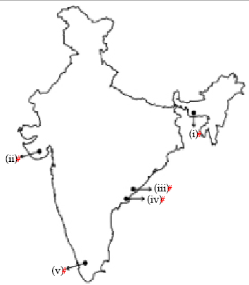
Answer : (i) Tharangambadi: Also known as Porayar, formerly Tranquebar, is a panchayat town in the Nagapattinam district of Tamil nadu, near the mouth of a distributary of the Kaveri River. It was a Danish colony. Danish Fort and other locations have made it famous as an important tourist destination.
(ii) Namcha Barwa: Namchabarwa is a mountain in the Tibetan Himalaya. It is the highest peak of its own section. It stands inside the Great Bend of the ....
Question : On the outline map of India provided to you, mark the location of all of the following. Write in your QCA Booklet the significance of these locations, whether physical/commercial/economic/ecological/environmental/cultural, in not more than 30 words for each entry:
(2014)
Answer : (i) Mudra port: Mundra Port is the largest private port of India located on the north shores of the Gulf of Kutch near Mundra, Kutch district, Gujarat. Formerly it was operated by Mundra Port and Special Economic Zone Limited (MPSEZ) owned by Adani Group which later it was expasnded into Adani Ports & SEZ Limited (APSEZ) managing several ports.
(ii) Chandipur: Chandipur, also known as Chandipur-on-sea, is a small sea resort in Baleswar District, Odisha, India. ....
Question : On the outline map of India provided to you, mark the location of all of the following. Write in your QCA Booklet the significance of these locations, whether physical/commercial/economic/ecological/environmental/cultural, in not more than 30 words for each entry:
(2014)
Answer : (i) Gurushikhar: Gurushikhar is the highest peak of Aravalli Range. It rises to an elevation of 1,722 meters (5,676 feet). It is named Guru - Shikhar or ‘the peak of the guru’ after Dattatreya, an incarnation of Lord Vishnu.
(ii) Bhorghat: Bhor Ghat is a mountain Passage between Khopoli and Khandala in Maharashtra, along the Old Mumbai Pune Road and the Mumbai Pune Expressway. Situated on the crest of the Western Ghats mountain ranges, Bhor Ghat ....
Question : On the outline map of India, mark the location of all of the following. Write the significance of these locations, whether physical / commercial / ecological /environmental / cultural, in not more than 30 words for each entry.
(2013)
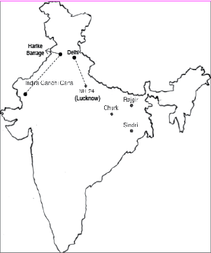
Answer : (i) Rajgir - It is a cultural place located in Bihar. It was the first capital of the kingdom of Magadha which evolved into Mauryan Empire. Its cultural importance also lies in the fact that it was associated with both Buddhism and Jainism. It was here that Gautam Buddha spent several months meditating and preaching sermon of Buddhism. It is a religious place for Jainism too as Lord Mahavira spent fourteen years of his life ....
Question : On the outline map of India mark the location of all of the following. Write the significance of these locations, whether physical / commercial / ecological /environmental / cultural, in not more than 30 words for each entry:
(2013)
Answer : (i) Mishmi Hills – Southward extension of great Himalayan ranges, these hills are on the north eastern tip of India, in central Arunachal Pradesh.
Geographically, it is divided into two sections, that is, flood plains of tributaries of Brahmaputra river and snow capped mountains of Arunachal. They are rich in flora and fauna, and many endemic species are found in parts of these hills.
(ii) Lipulekh Pass- It is a Himalayan pass which connects Kumaon region in ....
Question : On the outline map of India provided to you, mark the location of ALL of the following for which one (1) mark is given for each correct entry.
Write in your answer script the significant geographical relevance or strategic importance of these locations, whether physical/commercial/ economic/ecological/environmental/cultural in not more than 30 words for each entry. Three (3) marks are allotted for each write-up.
(2012)
Answer : (A) Manas: Manas National Park is located in Barpeta district of Assam. It is a tiger reserve. Elephant, tigers, Pygmy hogs and many other animals and birds are found here.
(B) Bachau: Bachau is located in Kachchh region of Gujarat. This town was reconstructed after Bhuj earthquake.
(C) Ganga river waterway from Allahabad: Ganga river after meeting Yamuna in Allahabad passes through Banaras, Ballia, Chhapra, Patna, West Bengal and finally merges into Bay of Bengal in ....
Question : On the outline map of India Provided to you, mark the location of any fifteen of the following for which 1 (one) mark is given to each correct entry. Write in your answer script the significance geographical relevance or strategic important of these locations, whether physical\ commercial\economic\ ecological\environmental cultural in not more than 30 words for each entry. 3 (three) marks are allotted for each write up.
(2009)
Answer : (i) Akarimata: It is a 250 MW power project coming at Chher in Kutch region of Gujarat. It is an ambitious undertaking of the Gujarat Mineral Development Corporation. It is also a lignite coal based power plant which will stand operating very soon.
(ii) Kolleru Lake: It is a fresh water lake situated in Andhra Pradesh. This lake is in the middle of Krishna and Godavari River basin. This is deltaic in origin.
(iii) Van Tivu: It ....
Question : Mark on the outline map of India supplied any ten of the following entries. Write brief notes (not exceeding 40 words each) on the significant aspects of the same ten entires.
(2008)
Answer : 1. Butcher Island: Butcher Island is an island off the coast of Mumbai. It is also known as Jawahar Dweep. It has an oil terminal used by the port authorities to offload it from oil tankers. It is a restricted area and most of the island is covered with dense vegetation. A hillock rises from the centre of the island.
2. Gopalpur Beach: Gopalpur is a unique beach. Located at a distance of 16-km from Berhampur ....
Question : Mark on the outline map of India supplied to you any ten of the following entries. Write brief notes (not exceeding 30 words each) on the significant aspects of the same ten entries:
(2007)
Answer : (a) Nagarjuna Sagar: It is a multipurpose project over River Krishna in Andhra Pradesh. It is an important source of irrigation in the Telangana plateau region.
(b) Dharmasala: It is a hill station and Buddhist centre in Himachal Pradesh. It is a place of exiled Dalai Lama of Tibet in India.
(c) Aizawl: It is the capital of Mizoram and important city of North-Eastern Region.
(d) Konkan Railway: Known for great work of engineering, Konkam Railway is 700 ....
Question : Mark on the outline map of India supplied, any ten of the following entries. Write brief notes (not exceeding 30 words) on the significant aspects of each entry:
(2006)
Answer : (I) Malaygiri: Mountain peak in Orissa, height 1187. This mountain is a part of Garhjat hills. In the Archean formation some important rocks are found-granite, quartz and slate.
(II) Sibsagar: Sibsagar is situated in Assam. It is an important oil field.
(III) Khetri: Khetri is situated in Jhunjunu district of Rajasthan and is known for large deposits of copper and integrated copper mining-cum-metallurgical unit.
(IV) Kolleru Lake: This fresh water lake lies between the deltas of River Godavari ....
Question : Mark on the outline map of India supplied any ten of the following entries. White brief notes (not exceeding 30 words) on the significant aspects of the same ten entries:
(2005)
Answer : I. Jawahar Lal Nehru Port: New mechanised port named Jawahar Lal Nehru port has been developed at Nhava Sheva, off the Mumbai port.
II.Chandra Bhaga River: River rises in the snow-covered Himachal mountains near Kullu formed by two streams which join at, Tandi near Kylong. After Kylong it’s called Chenab.
III. Kaimur Range: In Vindhyan Range, eastern part of this range which is not covered with Lava is known as the Kaimur and the Bhanrer Range in ....
