Question : Explain the drainage characteristics of Peninsular India.
(1994)
Answer : There are numerous rivers traversing the Penisnular India, the more important ones being the Damodar, Subarnrekha, Brahmani, Mahanadi, Godavari, Krishna, Kaveri and Tamraparni which flow into the Bay of Bengal and form delta. Some rivers like Banas, Chambal, Sindh, Son etc. belong to Katchchh or the Gulf of Cambay.
Following are the chief drainage characteristics of Peninsular rivers:
Question : Explain the geographical factors responsible for the growth of mangrove vegetation in India and discuss its role in coastal ecology.
(1993)
Answer : Trees have evolved according to specific stresses in the environment. One of these branches of evolution led to plants adapted to high salinity, categorised as halophytes. Halophytes growing in salty marshy areas are called Mangrove vegetation.
The geographical conditions favouring the growth of mangrove vegetation in India are tropical and sub-tropical coastlines—muddy banks of river estuaries, creeks, backwaters and along sea shores. Mangrove vegetation presents an outstanding example of influence of soil-moisture regime on natural vegtation. ....
Question : Delineate the flood prone areas of India by drawing a sketch map in the answer book and discuss the causes and consequences of floods in the North Indian Plains.
(1993)
Answer : Flood is a state of high water level that leads to inundation of land which is not normally submerged. Flood is a natural phenomenon but extent of its consequences in recent years has been largely determined by the human activities.
About 40 million hectares of country's area is prone to floods. Among these areas, the North Indian plain is the worst flood affected region of India accounting for more than 60 per cent of floods in ....
Question : How has India’s look east policy taken shape in the past two decades and how it may affect India’s external trade?
(2015)
Answer : Look East was introduced in the early 1990’s. For over two decades India’s look east policy was shaped the way the country deals with its neighbours in the Asia-pacific region, leading to substantially deeper economic, institutional and security relations.
In was initially aimed at diplomatic and economic engagement with Southeast Asia. But over the years, the policy has evolved into broader security and defence ties across the whole Asia—Pacific with India signaling its willingness to play ....
Question : Give a reasoned account of river water disputes related to the River Krishna.
(2015)
Answer : Krishna is the 4th biggest river in India after Ganges and Godavari river and Brahmaputra. It flows in the following states Maharashtra, Karnataka, Telangan and Andhra Pradesh. The Principle tributaries of Krishna are Ghataprabha, Malaprabha, Bhima, Tungabhadra and Musi.
Dispute is between Maharashtra, Karnataka and Andhra Pradesh.
There are many reasons for the water disputes among the states, some of them are—
Some of the states have more flow of rivers and they have enough water for ....
Question : Indian Island territories are vulnerable to the sea level rise. Explain
(2015)
Answer : It is not only the small island nations that needs to worry about sea level rise but countries like India who are having island territories and a vast coastline also need to worry. The various problems that make island territories vulnerable are—
Islands have their own continental shelves and a particular ecosystem in their coastal regions. Sea level rise poses the threat of flooding of these areas thereby impacting the ecosystem.
Large scale flooding impacts the ....
Question : Account for the growing frequency and intensity of floods in India and suggest short and long term remedial measures indicating the chronically flood pone areas.
(2015)
Answer : India has certain regions which are naturally prone to floods. Reasons for flooding are:
But in recent years the flood frequency and intensity has increased. Anthropogenic reasons have speeded up global warming. This has resulted into melting of glaciers at increased rate. This water starts flowing in rivers ....
Question : Explain the pattern of winter rainfall in India?
(2015)
Answer : India is a monsoon country. It receives most of the precipitation in 3-4 months from June—August. But, topography location also facilitates precipitation in other months as well. Winter rainfall forms this part of climate.
During winter, subtropical high pressure gets established over Indian landmass. And this trade winds starts moving from land to ocean. Though, only Tamil nadu coast receives rainfall. The trade winds moving from land to sea are offshore in the major part but ....
Question : Discuss the implications of India’s strategic location with reference to the Indian Ocean.
(2014)
Answer : The Implication of Indian Ocean for India
Indian occupies a central and strategic location in the Indian Ocean area. Its national and economic interests are inseparably linked with Indian Ocean.
Hence to keep the Indian Ocean as a zone of Peace free from superpower rivalry and increasing cooperation among littoral countries in the region has always been India’s foreign Policy’s goal for example Look East policy, Indian Ocean Rim Association for Regional Cooperation, BIMSTEC and Ganga-Mekong ....
Question : India is involved in a number of border disputes. Explain the reasons and remedies.
(2014)
Answer : The areas in contention with China and Pakistan are among the largest land-boundary disputes in the world. The Indo-Nepali dispute over Kalapani is more recent and involves a small area.
India-China (Aksai Chin and Arunachal Pradesh)
In the 1962 Sino-Indian War, China seized a Switzerland-sized area, Aksai Chin (Aksayqin), and overran Arunachal Pradesh. There are also other, smaller pockets of disputed area. The PRC withdrew from virtually all of Arunachal Pradesh to the Line of Actual Control ....
Question : Bring out the role of terrain in determining India’s political influence over neighbouring countries.
(2014)
Answer : Geography affects strategic and operational planning, tactics, logistics, operations, relations with civilian populations and the military evaluations of areas. A thorough knowledge of a broad range of geographic factors is necessary in order to effectively wield the elements of national power in pursuit of national interests. Thus terrain and topography plays an important role in determining political influence.
First, any credible military response to a regional conflict requires an understanding of the geography of that region, ....
Question : Describe the salient climatological characteristics of Rayalaseema region.
(2014)
Answer : The areas east of Karnataka upland and interior district of Andhra Pradesh, West of coastal lowland comprise this region. The eastern part of Bellary district is also included. This is a region of broad valley plains and low hills. The principal language is Telugu.
The Nallamala Ghat forms a part of this region, The Godavari, the Krishna and the Penner which drain this region have formed broad valley plains. The area lying to thesouth of Krishna ....
Question : Highlight the socio-economic and ecological roles of River Cauvery in its riverine tract.
(2014)
Answer : Socio-Economic Role
Ecological significance
Question : How is drainage pattern determined by the waterdivide.
(2014)
Answer : The flow of water through well-defined channels is known as ‘drainage’ and network of such channels is called as ‘drainage pattern’.
The drainage pattern of an area is an outcome of:
(which form water divide)
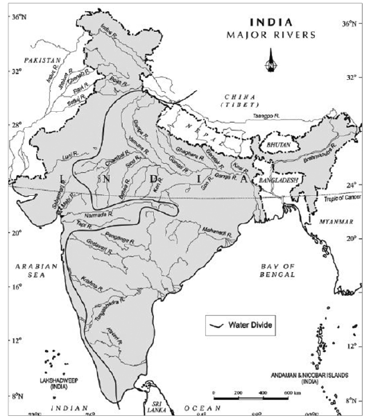
Geological time period has created a ‘waterdivide’ which is forming disaparities between the direction ....
Question : Differentiate between the ‘intensity’ and ‘magnitude’ of an earthquake and explain its varying impact in different parts of India.
(2014)
Answer : The point on the fault where slip starts is the Focus or Hypocenter, and the point vertically above this on the surface of the Earth is the Epicenter . The depth of focus from the epicenter, called as Focal Depth, is an important parameter in determining the damaging potential of an earthquake. Most of the damaging earthquakes have shallow focus with focal depths less than about 70 km. Distance from epicenter to any point of ....
Question : Explain the topographical and Structural characteristics of the Siwalik Range.
(2013)
Answer : Siwalik forms the outermost portion of the Himalayan mountain system, which is divided into three parallel ranges: Himadri (greater Himalaya), Himachal (lesser Himalaya) and the Siwaliks (outer Himalayas). Different opinions have been expressed by the scholars to explain its formation due to certain features like (a) the thickness of sediments in Siwalik ranges between 4500m. to 6100 m., (b) the sediments are newer in age, and (c) the deposits also contain marine fossils. The considerable ....
Question : Comment on the feasibility of interlinking of rivers of India and its possible contribution to resolution of water crisis.
(2013)
Answer : Indian Rivers Inter-linking project is a proposed large scale project that aims to join the majority of India Rivers of northern India with southern India to address the problems of water deficit in certain regions. The first such proposal was proposed by K.L.Rao, the then Minister of irrigation, to connect river Ganges and river Kaveri (2640 km link). In 1982, National Water Development Agency was set up to carry out surveys of the links and ....
Question : Identify the earthquake-prone zones and suggest strategy for their management. (
(2013)
Answer : An earthquake is a tremor of varying intensity in the earth’s surface caused by the action of the endogenetic forces of the earth. Geological Survey of India has divided India into five zones on the basis of this intensity:
Question : Explain the structure and characteristics of the Deccan plateau.
(2012)
Answer : Deccan Plateau was formed as sub continental plateau during Cretaceous and pre-tertiary period. It is spread over 5 Lakh sqkm in MP, Chhattisgarh, Andhra Pradesh, Maharashtra, Karnataka and Gujarat. It extends in east from Amarkantak (Surguja) to Kachchh in West, Tapti River in North to Belgaum in South and up-to Rajamundry in South East. The thickness of Lava decreases from west to east.
In the last stages of Cretaceous phase, a large part of sub-continental India ....
Question : Explain the causes, impact and remedial measures of flood-hazards in the middle Ganga plain. Represent the flood-affected areas of middle Ganga plain on a sketch map in your answer-book.
(2012)
Answer : The problem of flood has increased with increase in disturbance of nature due to development and increasing population. Middle Ganga plain is mainly drained by Son, Gomti, Gandak, Ghagra, Kosi, etc. Following are the reasons for problems in middle Ganga plain:
Question : Discuss the formation and the distribution of the major soil types of India.
(2009)
Answer : Soil is the thin surface-layer on the earth, comprising mineral particles formed by the breaking down of rocks, decayed organic materials, living organisms etc. Soil is formed under specific natural conditions. But the soil formation is influenced by few factors such as parent rock material, surface relief, climate and natural vegetation.
Geologically Indian soils can be broadly divided into two main types:
(a) Soils of peninsular India and
(b) Soils of extra peninsular India
The soils of peninsular ....
Question : Give reasons as to why rainfall versatility is a characteristic feature of India's mansoon.
(2009)
Answer : Indian monsoon is charaterised by great variability. Rainfall in India does not change with space only but with time also. There are large variations in the total amount of rainfall from year to year. This variability of annual rainfall is computed with the help of the following formula:
Co-efficient of variation (CV)
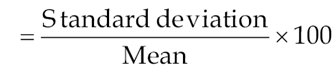
This co-efficient of variation indicates the amount of fluctuation recorded by rainfall over a long period of ....
Question : Distinguish between the West and East coasts of India in terms of their evolution, present topography and drainage pattern.
(2009)
Answer : The western and eastern coasts of India are part of the great India peninsular plateau. The plateau is a block of old crystal rocks. It was lifted above the level of sea in which these rocks were deposited in the Precambrian times and never submerged again. But the peninsular plateau has gone under many faulting and fracturing of the crust associated with vertical movements i.e. (upward or downward) due to forces generated by an accumulation ....
Question : Discuss the basis of identifying agro-climatic zones and explain the core strategies for agricultural development.
(2008)
Answer : Regionalization has been used for planning at the state level. Several methodologies have been used for regionalization depending on the purpose and ends. An important objective of most of these efforts was to evolve agro-ecological regional maps for the country in order to delineate comparable resource regions, for generating and transferring agro-technology to meet the country’s needs of food, fodder and fibre.
Most early attempts at regionalization were on the basis of broad natural regions, existing ....
Question : Distinguish between the Himalayan and the Peninsular drainage system.
(2008)
Answer : Owing to complex physiographic and lithological characteristics, and in accordance to long geological history, the river systems of India have formed various drainage patterns. The drainage systems have been classified according to the orientation, regional distribution and the mode of origin, the latter one being the most widely followed. According to the mode of origin, the Indian drainage system is divided into the Himalayan and the Peninsular.
The Himalayan drainage system rises in high mountains with ....
Question : Explain the different views put forth about the origin of Himalayas and divide Himalayas into verticle divisions.
(2007)
Answer : The Himalayas are one of the most complex mountain systems of the world. They represent a great variety of rock system dating back from Cambrian to Eoceneperiods and bear all important types of rocks.
The origin of Himalayas has been as complex as their relief features. There are two primary views regarding the origin of Himalayas:(i) the Geosynclinal evolution; and (ii) the Plate Tectonics evolution.
Geosynclinal Theory: As per the Geosynclinal evolution, put-forth by the scholars ....
Question : Give a critical account of the recent theories of origin of Indian monsoon with special reference to Jet Stream Theory.
(2006)
Answer : The theories regarding the monsoons are generally dividend into two broad categories:
(a) Classical Theory; and (b) Modern Theory.
Question : Discuss the role of spatial pattern of rainfall and temperature in the delimitation of climatic regions of India, especially with reference to Stamp’s climatic regionalization.
(2004)
Answer : Although India’s climate is broadly of tropical monsson type but vast size of the country, topographical differences, impact of sea, etc. have deep impact on climatic elements to exhibit marked variation and thereby create climatic variety at sub-regional level.
Among the climatic elements that exhibit spatial variation, the pattern of rainfall and temperature may provide the main basis for the delimitation of climatic regions of India. For example, the rainfall characteristics show various distinct regimes such ....
Question : Highlight the salient differences between the Himalayan and the Peninsular drainage system.
(2003)
Answer : India is a country of large extent having a variety of relief features, geological structures and climatic conditions. Owing to these factors and a long geological history, the rivers of India have formed varied drainage systems. On the basis of its mode of origin and geographical characteristics, the Indian drainage may broadly be divided into two categories:
(i) Drainage system of rivers originating from Himalaya mountain
(ii) Drainage system formed by the rivers of peninsular plataeu.
There is ....
Question : Explain the origin, mechanism and characteristics of Summer Monsoon in India.
(2002)
Answer : The climate of India is described by just one word “monsoon”. The word conveys comprehensively the idea of rythm of seasons and the changes that occur in the direction of winds. These changes lead to the changes in the seasonal distribution of rainfall and temperature.
Derived from the Arabic word ‘Mousam’, monsoon implies a seasonal reversal in the wind direction throughout the year. They flow from land to sea in the winter and from sea to ....
Question : Discuss the relief features of Indian Northern Plains.
(2001)
Answer : The Indian Northern Plains or the Great Plains is a transition zone between northern mountains and peninsular uplands in the south. It is an aggradational plain (depositional plain) formed by the depositional work of three major river systems viz. the Indus, the Ganga and the Brahmaputra, hence, also known as Indo-Gangetic- Brahmaputra plain.
The great plains of India is the largest alluvial tract of the world extending for a length of 3,200 km. from mouth of ....
Question : Explain the sequence of vegetation zones of the Himalayas.
(2001)
Answer : Altitude has profound impact on the sequence of vegetation zones in the Himalayas. This is because of the reason that with the increase in the altitude the temperature goes on decreasing. The Himalayas rise abruptly from the tropical heat to the heights of arctic cold. Therefore, there exists a sequence of vegetarian zones- from tropical to tundra in the Himalayas. Moreover, the eastern Himalayas are placed relatively near the tropic of Cancer and oceanic area ....
Question : Give a brief account of the second-order regions of Indian Peninsular Plateau.
(2001)
Answer : The Peninsular plateau consists of (1) Thar Desert, (2) Aravali Hills, (3) Central Vindhyan Uplands, (4) Khandesh and Satpura-Maikal ranges, (5) Chhotanagpur Plateau, (6) Meghalaya Plateau, (7) Kachchh and Kathiawar, (8) Gujarat Plains, (9) Konkan Coast, (10) Goa and Kanara Coast, (11) Kerala Coastal Plain, (12) Western Ghats, (13) Deccan Lava Plateau, (14) Karnataka Plateau, (15) Wainganga and Mahanadi Basins, (16) Telengana, (17) Southern Hills Complex, (18) Eastern Ghats, (19) Orissa Delta, (20) Andhra Coastal ....
Question : Explain the rise of the Himalayan ranges.
(1999)
Answer : As per postulates of Plate Tectonics, The origin and rise of mighty Himalayas is the result of collision between the Indian plate and Eurasian plate, both of which now contain continental portion along the collision boundary (a continent-continent collision). The major events can be summarised as follows:
Question : Elucidate the mechanism of the Indian Monsoon.
(1999)
Answer : Monsoons originally applied to the winds over the Indian ocean characterised by the seasonal reversals in the atmospheric pressure and wind system. Various explanations have been offered for its origin and mechanism:
Thermal Concept: This was first suggested by Halley who considered Monsoon as land and sea breezes on a gigantic scale. With the apparent northward movement of the sun, intense heating results into vast low area, from North West part to Tibetan highland, which attracts ....
Question : Evaluate the feasibility of the proposed Ganga-Cauveri drainage link.
(1998)
Answer : Ganga-Cauveri drainage link is part of the several links proposed recently for inter linking the rivers at national level. The present proposal assumed unprecedented significance in the backdrop of directive recently given by Supreme Court during a hearing of contentious Cauvery water dispute case and also because of severe drought experienced in 2002.
The idea proposed is to link the major rivers of whole India so that floods can be mitigated from the diversion of excess ....
Question : Draw a sketch-map in your answer-book to delineate the main climatic regions of India and discuss the important climatic characteristics of each region.
(1996)
Answer : Although broadly speaking India's climate is of tropical monsoon type but large size and physical variations have created climatic variety at regional level. Several attempts have been made to divide India into various climatic regions. Treewartha's classification of climate which is in itself a modified form of Koppen's scheme corresponds with the vegetative and even geographical regions of India in a fair manner. Here treatment of climatic regions is based on the Treewartha's scheme. Four ....
Question : Examine the origin and characteristics of the antecedent drainage system of the Himalayas.
(1996)
Answer : The Himalayan rivers, which now belong to the three principal systems (th Idnus, the Ganga and the Brahmaputra) have evolved through a long period of geological hisetory. According to geologists, the Tibetan plateau was drained to the west by mighty Tsangpo Indus Oxuscombine called the Tibetan river. Similarly another big river called Inod-Brahman or the Siwalik traversed the centire longitudinal extent of Himalayas from east to North west.
Later the mighty Siwalik river was dismembered into ....
Question : Discuss the distribution and characteristics of the evergreen forest in India.
(1996)
Answer : Also known as rainforests, the tropical evergreen forests are of three types, viz., the wet evergreen the semi evergreen and dry evergreen forests.
Tropical Wet Evergreen Forest: These forets are mainly found in North-East India, Western parts of Western Ghats and Andaman-Nicobar islands where the amount of rainfall is more than 250cm/year. These forests are very dense and composed of tall trees, epiphytes, parasites, lianas and rattans so as to look like a green carpet. Trees ....
Question : Examine the origin and characteristics of the soils of the North Indian Plain.
(1995)
Answer : The North Indian Plain is covered mainly with the riverine alluvial soils. It is an aggradational plain formed by the alluvial deposits of the Indus, Ganga and the Brahmaputra and their tributaries coming from Himalayan and the Peninsular regions.
The origin of these soils is related to the origin of the Northern Plains itself. According to recent views the region represents a sag in the crust formed between the northward drifting of the Indian Plateau and ....
Question : Draw a sketch map in your answer book to delineate the main physiographic regions of India and provide a reasoned account of the relief and structure of the Himalayan region.
(1995)
Answer : The differences in the relief features is largely due to differences in the geological history and structure and Himalayan region is no exception to it. Himalayan are tectonic in origin and present a very youthful relief because of their comparatively recent evolution. They are one of the complex mountain systems of the world representing a great variety of rocks.
According to the most accepted postulates of Plate Teconics Theory, the origin and rise of mighty Himalayas ....
Question : Describe the structure and relief features of peninsular India.
(1995)
Answer : Landforms are a function of structure, process and stage. The relief and landforms that we see today have been the product of long process of weathering, erosion, sedimentation, deposition, compaction, metamorphism, intrusion, magnetism, Subsidence, Upliftment, and a combination of many other processes. The most extensive physical division of India is the peninsular plateau whose relief features are manifestation of its geological history and structure.
To understand the present physiographic features properly what is needed is a ....
