Question : Discuss the concept of multilevel planning as practiced in India, and explain the implications of 73rd and 74th constitutional amendments in this respect.
(2015)
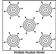
Answer : Multilevel planning may be defined as planning for a variety of regions which together form a system and subordinate system.
In multilevel planning, the various levels of planning provide bases for higher level planning. In this every region/unit constitutes a system and planning process becomes more effective.
In the context of multilevel planning in India the various levels can be discussed as follows—
First level planning — It is constituted by the central government. The business of ....
Question : Is planning for a cluster of villages a viable option, when planning for backward areas of the country? Discuss with suitable example.
(2015)
Answer : Backward area planning in India is facilitated through backward region grant fund which was approved by Cabinet Committee on Economic Affairs in 2006. It aims to accelerate socio economic development in the concerned states by bridging critical gaps in local infrastructure and addressing other developmental needs.The programmes under the fund are implemented by state governments. In present form, fund has two components: District component and State component.
Recently there have been plans to dwell deeper into ....
Question : Reduction in regional disparities has been one of the priority goals of national planning in India. How the proposed new smart urban centre may contribute to the process?
(2015)
Answer : In the regional development and growth, Indian planning was initially focused on trickle down theory i.e. develop certain centers first and when they will grow, the growth will spill over to the nearby regions.
But this has not given the expected results. It has resulted in regional disparity. It is quite visible that India has cartain regions in which people are below poverty line ....
Question : In population planning, the thrust of the government has been ‘planning the population’ not ‘plan for the population’ elaborate.
(2015)
Answer : The phenomenal growth of Indian population has created numerous problems which find their manifestation in economic under development and socio-political unrests in different states and regions of the country. The main objective of economic and social development to improve the quality of life and social well being of the millions remains a distant dream.
In fact, over 26% of the total population i.e. over 200 million are below the poverty line who are not earning even ....
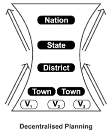
Question : Decentralized planning through the strengthening of Panchayat system is the focus of planning in India in recent times. Suggest a blueprint for an integrated regional development plan.
(2015)
Answer : As it has been recognized that bottom up approach instead of top down approach will lead to sustainable development, decentralized planning has become the focus of planning in India in recent times.
Decentralized planning is called part in integrated regional development plan as integrated planning focuses on all aspects of development of the region. In general, four aspects are included in integrated regional planning. One is sectoral cum temporal integration
Question : Discuss the relationship of watershed approach to village planning.
(2015)
Answer : Watershed management is a comprehensive Programme to utilize the available water and other resources in such a way that the productivity of agriculture is enhanced, the allied activities of industries are promoted, social forestry is encouraged to provide an additional source of income, soil erosion is checked, cottage industries are developed, more employment opportunities are created, the space available is made more enjoyable and ecology is maintained in a healthy and sustainable condition. Now village ....
Question : Evaluate the Backward Regions Grant Fund Programme.
(2014)
Answer : The Backward Regions Grant Fund Programme (BRGF), signifies a new approach to addressing persistent regional imbalances in development. The BRGF Programme covers 250 districts in 27 States, of which 232 districts fall under the purview of Parts IX and IX-A of the Constitution dealing with the Panchayats and the Municipalities, respectively.
The remaining 18 districts are covered by otherlocal government structures, such as Autonomous District and Regional Councils under the SixthSchedule of the Constitution and ....
Question : Discuss the concept of Command Area Development and evaluate its success with reference to Indira Gandhi Canal.
(2014)
Answer : During the post independence era, a large number of irrigation projects were constructed for increasing agricultural production in the country.Subsequently an analysis of irrigation potential created and utilised revealed that there was a substantial gap between them. The Irrigation Commission made specific recommendations in its report in 1972 that systematic development of command areas of irrigation projects should be taken up in order to fully utilise the irrigation potential created.A Committee of Ministers set up ....
Question : How can a meaningful skill development programme contribute to the economic growth of hill areas?
(2014)
Answer : The hill areas of the country, particularly the Himalayan and the Western Ghats regions which constitute about 21 per cent of the total area and contain 9 per cent of the total population of the country, support the basic life-giving natural resources but have fragile and sensitive eco-system.Meaningful skill development programme if implemented could be of immense help for hilly regions.
Skill can be imparted through:
Industries: The hill areas are particularly suited to industries which require ....
Question : Account for the multiple problems of urban agglomerations.
(2014)
Answer : India is one of the less urbanized countries of the world. With only 31.16 per cent of her population living in urban agglomerations/towns, this country is facing a serious crisis of urban growth at the present time. Whereas urbanisation has been an instrument of economic, social and political progress, it has led to serious socio-economic problems.
Some of the major problems of urbanisation in India are
1. Urban Sprawl: Urban sprawl or real expansion of the ....
Question : Analyse the feasibility of ‘Smart Towns’ Development in India.
(2014)
Answer : Across the world, the stride of migration from rural to urban areas is increasing. By 2050, about 70 per cent of the population will be living in cities, and India is no exception. It will need about 500 new cities to accommodate the influx.
Interestingly, urbanisation in India has for the longest time been viewed as a by-product of failed regional planning. Though it is inevitable, and will only change when the benefits of urbanisation overtake ....
Question : Describe how urbanization creates air and water pollution in India.
(2013)
Answer : Urbanization is the process of transformation of society from a predominantly rural to a predominantly urban population. Due to increase in influx of such society and also due to various other factors having an impact on urbanization, there has been a considerable increase in pollution level too.
Impact of urbanization on air pollution: There has been an increased use of transport along with simultaneous uncontrolled growth of vehicles leading to generation of smoke. Poor quality of ....
Question : Write a note on the emergence of National Settlement System in colonial India and discuss the factors contributing to urbanization in post-independence period.
(2013)
Answer : With the arrival of the British East India Company, the nature of urbanization process changed remarkably.
The major contribution of the British to the Indian urban scene were: (1) the creation of three metropolitan port cities of Mumbai (Bombay), Kolkata (Calcutta) and Chennai (Madras), (2) creation of a chain of hill stations in the Himalayan region and in South India,(3) the modification of the urban landscape of the existing cities with the introduction of civil lines ....
Question : Planning and development of ‘Tribal Regions’ in India.
(2013)
Answer : ‘Tribal Regions’ are spread across the country mainly in the forest and hilly regions of Madhya Pradesh, Maharashtra, Odisha, Bihar, and Andhra Pradesh, West Bengal and Gujarat. The essential characteristics of these communities are primitive traits, geographical isolation, distinctive culture, shyness of contact with communities at large and backwardness.
In first five year plan, principle of ‘TRIBAL PANCHSHEEL’ has been adopted where focus has been on ‘Integration of Tribal people rather than assimilation’. ‘Tribal Development Block’ ....
Question : City-regions as territorial unit for regional planning and development.
(2013)
Answer : Regional planning is a technical and political process concerned with the use of land and design of the urban environment, including transport network, to guide and ensure the orderly development of settlements and communities.
City as a unit of regional planning generally represents a region of multiple administrative districts but shared resources like central business districts, labor market and transport network such that it forms a single unit.
Regional planning requires various land use, protection of farmland, ....
Question : What do you understand by ‘Young India’? How can the present state of population composition be converted into an asset for the country?
(2013)
Answer : ‘Young India’ defines the population groups which are in the age of 13-35 years and are the most productive work force of Indian economy.
The present state of population composition can be converted into an asset for the country by focusing on the aspects of:
Question : Elucidate the role of Tribal Development Blocks in the development of Tribal areas.
(2012)
Answer : Tribals are economically, educationally backward people living in harsh geographical conditions. They have their own unique cultural identity. Tribal development blocks (TDB) were constituted for development of tribal areas. A TDB include area of size 150-250 sq km and population of 25000. Two types of strategies are followed for tribal regions. First is marginal area development agency for tribal area with population less than 5000 and second is tribal sub-plan with population more than 5000. ....
Question : Morphological characteristics of villages situated in hilly regions.
(2012)
Answer : Morphology of villages includes study of settlement pattern, and its internal functional and structural features. Geographical features do have clear impact on rural morphology along with social structure. Single houses to series of houses on slopes are seen in hilly regions. Rough terrain, cold climate,
water availability decides the location of settlement in hilly regions. The higher reaches, for example in Himalayas, are inhabited by Gujjar tribe in single room houses.
Scattered settlements are found in ....
Question : Giving reasons identify the chronic drought-prone areas of India.
(2009)
Answer : According to high powered committee on disaster management report, any lack of water to satisfy the normal needs agricultural, livestock, industry or human population may be termed as a draught. This condition occur either due to inadequacy of rainfall or lack of irrigation facilities or deficient availability of water for meeting the normal crop requirements in context of the agro-climatic conditions prevailing in any particular area. This condition of drought is measured scientifically as moisture ....
Question : Discuss the problems and prospects of development of catchment and command areas.
(2008)
Answer : A catchment is an area of land that collects water, which drains to the lowest point in the area which could be either a lake, a dam, or the sea. Rain falling on the land will make its way to this lowest point, via creeks, rivers and stormwater systems.As well as rivers, creeks, lakes and dams, a catchment also includes groundwater, stormwater, waste water, and water-related infrastructure
The Command Area Development Programme aims mainly at reducing ....
Question : Discuss the policies and programmes of Integrated Rural Development Programmes in India?
(2007)
Answer : To revitalise the Indian rural economy and society, many schemes and programmes were initiated in post independence era. Out of those, the Integrated Rural Development Programme (IRDP) has been exemplary.
The IRDP aims at providing assets and self-employment opportunities to the rural poor. The assistance under IRDP is given to a target group of rural poor belonging to families below poverty line, in the form of subsidy by government and in the form of term-loan by ....
Question : Explain the process and patterns of regional disparities in India and suggest suitable measures for bringing about the regional balance.
(2006)
Answer : Regional disparity is a world-wide phenomena. What differentiates the problem of the under - developed countries like India from that of the developed countries is the fact that whereas in the latter all inhabitants have an assured minimum level of subsistence, the concern of lagging regions is just to ‘catch up’.
There is a marked regional disparity in the level of development within the country. India is a diverse country with uneven distribution of almost all ....
Question : Discuss the elements and approaches of town planning in India.
(2006)
Answer : The importance of town planning was realised in the post-indpendence period. considering the heavy demand by various activities like industrial, commercial, residential, recreational etc. on urban land, there is need for scientific principles governing the allocation. Besides these functions, the width of roads should be kept in mind considering the future density of traffic.
A Town Planning Authority prepares the land use plan for towns, demarcating different zones for specific landuse. These plans include the provision ....
Question : Examine the relationship between geography and regional planning.
(2005)
Answer : Geography is that subject which basically deals with the analysis of areal differentiationand areal organisation. The area here connotes the region. In other words, geography is science of distribution,
organisation and analysis of regional facts. As far as regional development is concerned, it requires the works of planning for the development of an unit of landscape (region). Therefore a region is essential for any planning and geographical knowledge is sine-qua-non for a region. Hence any ....
Question : Examine the regional development policy of India in various Five Year Plans.
(2004)
Answer : The size of our country is large enough to exhibit considerable variations in physical conditions and resource availability, which, coupled with some historical factors, has resulted into differential levels of socio-economic development in various regions. Moreover, expectations and problems of different regions also differ. Addressing such problems and concerns becomes very important in the federal nature of polity we have.
It is in this respect that regional development policy implemented through the planning process holds much ....
Question : Identify the drought prone areas of India and discuss the measures for their development.
(2003)
Answer : Droughts in India are closely and intricately linked with the vagaries of monsoon. Droughts are more frequent in areas of low (below 60 cm) and variable rainfall (variability above 40%), where irrigation fcilities are not well-developed.
Three types of drought prone areas are identified taking the combined effect of intensity and periodicity of rainfall, ground water potential and agricultural production.
Question : Explain the concept of Command Area Development.
(2003)
Answer : In order to ensure faster and better utilisation of irrigation, water available from multipurpose projects shown in the figure given below, the centrally sponsored Command Area Development Programme was launched in the beginning of the Fifth Plan period.
The programme involves execution of on farm development works like construction of field channels and field drains, land levelling and shaping and conjunctive use of surface and ground water. Other items of work are warabandi or rotational system ....
Question : Explain the causes of regional disparities in the economic development of India.
(2003)
Answer : The co-existence of relatively developed and under developed states and even regions within states is known as regional disparities. Regional disparities may occur due to two reasons. Firstly, it may be because of non-development, i.e. where developmental works are not undertaken, the region lags behind in economic development. Secondly, it may occur as a by product of development. For instance, per capita income at the current price of 2000-01 varies at a large scale, like ....
Question : Present an account of the experience of regional planning in India in the context of Damodar Valley.
(2003)
Answer : A river basin is regarded as a natural unit for regional planning. The river basin planning approach is based on water induced development, where better water management is expected to stimulate development process in rest of the economy. Damodar river valley is the first river basin of the counrty selected for regional planning.
The river Damodar is a tributary of the Hugli river and flows across Jharkhand and West Bengal for about 541 km. Its basin ....
Question : Discuss the programmes and policy of development of dry areas in India.
(2003)
Answer : Dry land areas are those parts of the country which receive 75 cm to 100 cm rainfall (therefore face moisture deficiency for 2/3 part of the year) and those semi-arid parts which receive 30-75 cm rainfall (therefore, face moisture deficiency throughout the year). Such areas cover Punjab, Haryana, South-western Uttar Pradesh, Western Madhya Pradesh, Rajasthan, Gujarat, interior regions of Maharashtra, rain shadow areas of Karnataka, Tamil Nadu and Andhra Pradesh.
Besides low rainfall, these dry regions ....
Question : Give a reasoned account of regional disparities in economic development in India and bring out the contribution of decentralised planning in solving this problem.
(2002)
Answer : A region is a perceived segment of space differentiated from others on the basis of one or more defining characteristics and the basic criterion in the limitation of region seems to be relative uniformity or homogeneity of geographical phenomena over space.
Regional disparity is said to occur when one region shows greater development on economic and human indexes while the others look laggards. This lopsided development takes place primarily for two reasons.
The physical/geographical causes will include ....
Question : Provide the geographical background and characteristics of the distribution of Hill Stations of India.
(2001)
Answer : Hill stations are the cool places of tourist attractions on high elevation in a mountainous or plateau region. The development of hill stations has been the product of colonial period in India. Existence of lofty mountains of Himalayas in the northern part of India has presented many sites for the development of hill stations. Consequently, many hill stations having an average elevation of 1500-2000 metres above mean sea level have emerged on the Himalayan ranges ....
Question : Explain the concept of watershed and its utility in land management.
(2001)
Answer : In India, about 75% of the cultivable landdepends on in situe rainfall which contribute only 50% of the national procuction. Production from unfavourable area can be stabilized or even improved by reducing run off to conserve more water or by supplementary irrigation. Watershed development can be an effective approach in this regard.
The model of watershed development is an agreeable measure to achieve sustainable development. Watershed development approach is basically driven by the concern of balancing ....
Question : Explain the concept of multi-level planning in India.
(2000)
Answer : A planning process can be either single level or multi level. The concept of multi level planning may be defined as planning for a variety of regions which together form a system and subordinate Subsystems. In this planning, the National Territory is devided into small territorial units whose numbers depend upon the size of the country, its administrative geographical and regional structure. Here Lower level planning provides bases for higher level planning. Likewise higher level ....
Question : Nature and Utility of multi-level planning in India.
(1999)
Answer : In the multi level planning, the national territory is divided into small territorial units, their numbers depending upon the size of the country, its administrative geographical and regional structure. The concept of multi-level planning may be defined as planning for a variety of regions which together form a system and subordinate sub-systems. Here lower level planning provides bases for higher level planning. Likewise higher level regional plans provide frame works for lower-level areal plans.
Following six ....
Question : Evaluate the benefits of Block level development planning in India.
(1997)
Answer : Block is a unit of planning and administration below district and above village created for the first time during First Five Year Plan to supervise the implementation of development plans under the Community Development Programme M.L. Dantwala Working Group on Block Level Planning appointed by Government in 1977 felt that block is a relevant unit of planning because it is distinguished by a certain community of interest and is sufficiently small in terms of area ....
Question : Draw a sketch map of India showing major river basins. Examine the feasibility of the concept of river basins as a planning unit.
(1997)
Answer : River basin includes the area drained by the main river and its tributaries. It is an appropriate physically and socially integrated region and may be used as an ideal unit of planning.
The concept of river basin planning is not new. The oldest recorded practice of irrigated agriculture has been traced in Tericho in 7000 B.C. Ancient texts found in China, Egypt and Iraq indicate the remarkably sound knowledge about the hydrological cycle, ecological balance between ....
Question : Explain the salient features of the tribal development programme with particular reference to either Dandakaranya or Chotanagpur.
(1996)
Answer : Government of India has specified some 550 communities in the schedule of tribes. According to 1991 census tribals have a population of 67.7m (8.08% of total population of India). Geographically, they exhibit concentrations in three broad zones—north-eastern hills & forested areas; hills and forest stretches in central India extending from east to west; and in the island chains particularly Andaman & Nicobar islands. Tribal development programmes are designed keeping in mind their specific characteristics like ....
Question : Give the hierarchy of planning regions and bring out the role of metropolitan planning in fostering regional development in India.
(1995)
Answer : India has been divided into 13 macro planning regions and 35 meso-regions with further subdivisions of meso-regions into micro regions, though this is not a comprehensive list.
I.South Peninsular (incarporating Kerala and Tamil Nadu) with Coimbatore, Cochin & Chennai as prominent nodes.
1.Kerala economy centred around plantations, teak, coconut, thorium & hydro-potential.
2.Chennai-Coimbatore industries region-main industrial textile, sugar cane and oil seed crushing and mineral resources-Meyudi lignite, iron ore.
3.Tamil Nadu coastal plain: Agriculture in delta region, agro-industries, fisheries, ....
