India State Of Forest Report –2019
- 03 Jan 2020
- Recently, the ministry for Environment, Forest and Climate Change released the biennial “India State of Forest Report (ISFR)-2019, providing an assessment of the country's forest resources.
- The report provides information on forest cover, tree cover, mangrove cover, growing stock inside and outside the forest areas, carbon stock in India’s forests, Forest Types and Biodiversity, Forest Fire monitoring and forest cover in different slopes & altitudes.
Objectives
- To monitor forest cover and changes therein at the National, State and District levels
- To generate information on forest cover in different density classes and changes therein
- To produce forest cover and other thematic maps derived from it for the whole country
- To provide primary base layer for assessment of different parameters including growing stock, forest carbon
- To provide information for international reporting
About the India State of Forest Report (ISFR)
- The report is published by the Forest Survey of India (FSI) which has been mandated to assess the forest and tree resources of the country including wall-to-wall forest cover mapping in a biennial cycle.
- Starting from1987, 15 assessments have been completed so far. ISFR 2019 is the 16th report in the series.
Major Findings
Total Forest Cover
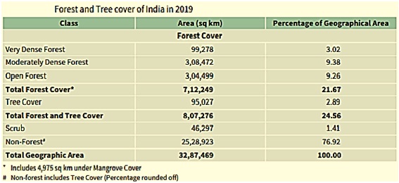
- The total forest cover of the country is 7,12,249sq km which is 21.67% of the geographical area of the country. The tree cover of the country is estimated as 95,027 sq km which is 2.89% of the geographical area.
- The total Forest and Tree cover of the country is 8,07,276sq km which is 24.56% of the geographical area of the country.
- It shows an increase of 3,976 sq km (0.56%) of forest cover, 1,212 sq km (1.29%) of tree cover and 5,188 sq km (0.65%) of forest and tree cover put together, at the national level as compared to the ISFR 2017.
Forest Cover in States
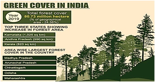
- Area-wise Madhya Pradesh has the largest forest cover in the country followed by Arunachal Pradesh, Chhattisgarh, Odisha and Maharashtra.
- The top five States in terms of increase in forest cover are Karnataka (1,025 sq km), Andhra Pradesh (990 sq km), Kerala (823 sq km), Jammu & Kashmir (371 sq km) and Himachal Pradesh (334 sq km).
- In terms of forest cover as percentage of total geographical area, the top five States are Mizoram (85.41%), Arunachal Pradesh (79.63%), Meghalaya (76.33%), Manipur (75.46%) and Nagaland (75.31%).
Forest Cover in North East Region
- Total forest cover in the North Eastern region is 1,70,541sq km, which is 65.05% of its geographical area. The current assessment shows a decrease of forest cover to the extent of 765 sq km (0.45%) in the region. Except Assam and Tripura, all the States in the region show decrease in forest cover.
Forest Cover in Hill and Tribal Districts
- It shows an increase of 544 sq km (0.19%) in 140 hill districts of the country.
- The current assessment shows a decrease of 741 sq km of forest cover within the RFA/GW in the tribal districts and an increase of 1,922 sq km outside.
Mangrove
- Mangrove cover in the country has increased by 54 sq km (1.10%) as compared to the previous assessment.
- Top three states showing mangrove cover increase are Gujarat (37 sq km) followed by Maharashtra (16 sq km) and Odisha (8 sq km).
Total Carbon Stock
- The total carbon stock in country’s forest is estimated 7,124.6 million tonnes and there an increase of 42.6 million tonnes in the carbon stock of country as compared to the last assessment of 2017. The annual increase in the carbon stock is 21.3 million tonnes, which is 78.2 million tonnes CO2 eq.
Wetlands
- There are 62,466 wetlands covering 3.83% of the area within the Recorded Forest Area/Green Wash(RFA/GW) of the country.
- The total number of wetlands located within the RFA/GW is 8.13%. Amongst the States, Gujarat has largest area of wetlands within RFA in the country followed by West Bengal.
Fire Prone Areas
- Fire prone forest areas of different severity classes have been mapped in the grids of 5km x 5km based on the frequency of forest fires. The analysis reveals that 21.40% of the forest cover of the country is highly to extremely fire prone.
|
Forest Cover
Recorded Forest Area
Green Wash
|
Significance
- It provides relevant information pertaining to each State such as biodiversity assessment, slope and altitude wise forest cover which would be very useful in formulating policies and strategies for conservation, management and enhancement of their forest and tree resources.
- The report contains dedicated chapters on Bamboo Resources, Forest Fires, Carbon Stock, People and Forests and Forest Types and Bio-diversity. It will be of great relevance to the entire spectrum of stake holders from the policy makers, academicians, administrators, forest managers, and community based organizations to the citizens of the country at large.
- In tune with the Government of India’s vision of Digital India, FSI’s assessment is largely based on digital data whether it is satellite data, vector boundaries of districts or data processing of field measurements.
Forest Survey of India (FSI)Headquarters: Dehradun, Uttarakhand
|