India State of Forest Report 2021
- 14 Jan 2022
On 13 January 2022, the Union Ministry for Environment, Forest and Climate Change has released the biennial ‘India State of Forest Report 2021’ prepared by the Forest Survey of India (FSI).
- The ISFR-2021 provides information on forest cover, tree cover, mangrove cover, growing stock, carbon stock in India’s forests, forest fire monitoring, forest cover in tiger reserve areas, above ground estimates of biomass using SAR data & climate change hotspots in Indian forests.
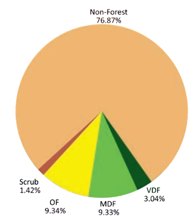
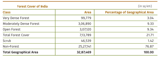
(OF: Open Forest; MDF: Moderately Dense Forest; VDF: Very Dense Forest)
Major Findings
Forest and Tree Cover
- The total forest and tree cover of the country is 80.9 million hectare which is 24.62 per cent of the geographical area of the country.
- Increase in Forest & Tree Cover: As compared to the assessment of 2019, there is an increase of 2,261 sq km in the total forest and tree cover of the country. Increase in forest cover has been observed in open forest followed by very dense forest.
- Forest Cover: 1,540 sq km
- Tree Cover: 721 sq km.
- Top Three States Showing Increase in Forest Cover: Andhra Pradesh (647 sq km) followed by Telangana (632 sq km) and Odisha (537 sq km).
- Area-wise Largest Forest Cover: Madhya Pradesh has the largest forest cover in the country followed by Arunachal Pradesh, Chhattisgarh, Odisha and Maharashtra.
- Forest Cover as Percentage of Total Geographical Area: In terms of forest cover as percentage of total geographical area, the top five States are Mizoram (84.53%), Arunachal Pradesh (79.33%), Meghalaya (76.00%), Manipur (74.34%) and Nagaland (73.90%).
- 17 states/UT’s have above 33 Percent of the Geographical Area Under Forest Cover: Out of these states and UT’s, five states/UTs namely Lakshadweep, Mizoram, Andaman & Nicobar Islands, Arunachal Pradesh and Meghalaya have more than 75 per cent forest cover while 12 states/UTs namely Manipur, Nagaland, Tripura, Goa, Kerala, Sikkim, Uttarakhand, Chhattisgarh, Dadra & Nagar Haveli and Daman & Diu, Assam, Odisha, have forest cover between 33 per cent to 75 per cent.
Mangrove Cover
- Total mangrove cover in the country is 4,992 sq km.
- An increase of 17 sq Km in mangrove cover has been observed as compared to the previous assessment of 2019.
- Top three states showing mangrove cover increase are Odisha (8 sq km) followed by Maharashtra (4 sq km) and Karnataka (3 sq km).
- Carbon Stock
- Total carbon stock in country’s forest is estimated to be 7,204 million tonnes and there an increase of 79.4 million tonnes in the carbon stock of country as compared to the last assessment of 2019.
- The annual increase in the carbon stock is 39.7 million tonnes.
|
The carbon stock refers to the amount of carbon stored in forests in the form of biomass, soil, deadwood and litter. More the carbon stock, higher would be the forest's capacity to absorb and sequester carbon dioxide (CO2), the main greenhouse gas in the atmosphere, through photosynthesis. |
|
Forest Category & Cover
|
Some New Features of isfr 2021
- Assessment of forest cover in the Tiger Reserves and Lion Conservation Areas: In the present ISFR 2021, FSI has included a new chapter related to the assessment of forest cover in the Tiger Reserves, Corridors and Lion conservation area of India.
- Above Ground Biomass: A new initiative of FSI has also been documented in the form of a chapter, where the ‘Above Ground Biomass’ has been estimated. FSI, in collaboration with Space Application Centre (SAC), ISRO, Ahmedabad, initiated a special study for estimation of Above Ground Biomass (AGB) at pan-India level, using L- band of Synthetic Aperture Radar (SAR) data.
- Mapping of Climate Change Hotspots in Indian Forests: FSI in collaboration of with Birla Institute of Technology & Science (BITS) Pilani, Goa Campus has performed a study based on ‘Mapping of Climate Change Hotspots in Indian Forests’. The collaborative study was carried out with the objective to map the climatic hotspots over the forest cover in India, using computer model-based projection of temperature and rainfall data, for the three future time periods i.e. year 2030, 2050 and 2085.