IMD revises Long Period Average (LPA) of Rainfall
- 15 Apr 2022
The India Meteorological Department (IMD), in its first prediction of this year’s monsoon trends, has introduced a new benchmark figure based on 1971-2020 data, showing marginal decline in monsoon rains and overall annual showers in the country over the long period of time.
- The new updated rainfall normal has been prepared based on data of 1971-2020 and will replace the existing rainfall normal based on 1961- 2010 with effect from the southwest monsoon season 2022.
- Under the new ‘rainfall normal’ figure, all-India rainfall for the southwest (summer) monsoon is 87 cm, based on 1971-2020 data, as against the earlier normal figure of 88cm based on 1961-2010 period.
- Till 2018, the IMD used 89cm, based on a 50-year average from 1951-2000, as the ‘normal’ rainfall benchmark for the monsoon season.
|
Long Period Average
LPA Averages over the Decades
|
Why this Revision?
- The revision is part of a periodic update on the normal rainfall figures.
- The rainfall normal is prepared based on the data for the period of 50 years and is updated periodically once in every decade by incorporating the latest data from raingauge stations.
When a monsoon is considered ‘normal’?
- A monsoon is considered “normal” when rainfall falls between 96% and 104% of the LPA.
How the rainfall normal has been computed?
- New rainfall normal has been computed using rainfall data of 4,132 rain gauge stations well distributed over the country, representing 703 districts.
How will be the monsoon for this year?
- In its first-stage long range forecast for the 2022 southwest monsoon, the India Meteorological Department (IMD) has forecast normal rainfall for 4th year during the season.
|
No El Nino
|
Other Findings by IMD
- State that receives maximum rainfall in southwest monsoon season: The IMD's findings, based on analysis of 50-year data, show that the Gujarat region receives maximum rainfall i.e. 96% of its annual rainfall in southwest monsoon season.
- State that receives maximum rainfall in northeast monsoon season: Tamil Nadu receives maximum rainfall i.e. 48% of annual rainfall in northeast monsoon season (October-December) followed by 36% in southwest monsoon season.
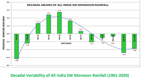
Current Epoch of Southwest Monsoon
- Presently the southwest monsoon is passing through a dry epoch which started in the decade of 1971-80.
- The decadal average of all India SW monsoon rainfall for the decade 2011-20 is -3.8% (minus 3.8%) from the long-term mean.
- The next decade i.e. 2021-30 is expected to come closer to neutral and southwest monsoon would enter into the wet epoch from the decade 2031-40 - an indication that the wet spell may increase the rainfall in future.
- The IMD attributed decrease in average normal rainfall to “natural multi-decadal epochal variability of dry and wet epochs” of all India rainfall.
|
Dry Epoch vs. Wet Epoch
|