All-Weather Radar Imaging Satellite
- 22 May 2019
Why is it in News?
RISAT-2B satellite was launched on May 22 from Sriharikota and it marked the resumption of a vital ring of Indian all-seeing radar imaging satellites. Two were launched earlier in 2009 and 2012.At least a half-dozen could be launched in the near future. These would provide reconnaissance capability from about 500 km in space and a comprehensive vigil over the country.
Benefits of radar satellites:
- When it is cloudy or dark, regular remote-sensing or optical imaging satellites which work like a light-dependent camera cannot perceive hidden or surreptitious objects on the ground.
- However, radar satellites are equipped with an active sensor, the synthetic aperture radar (SAR), which can sense or ‘observe’ Earth in a special way from space day and night, rain or cloud which makes them special for security forces and disaster relief agencies.
- Radar imaging satellites pick up structures, new bunkers very well, and sometimes help to count them, too.
- In India radar imaging is used for crop estimation because the main crop growing season of kharif is in May-September when it rains and gets cloudy. Radar data has been used extensively for forestry, soil, land use, geology and during floods and cyclone.
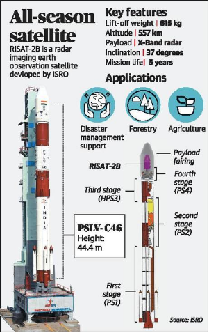
About RISAT-2B
- It has a mass of 615 kg and will orbit at 555km distance from the earth and is built for a 5-year operational lifetime.
- The satellite will be capable of monitoring weather day and night, in all weather conditions.